This video presents a compelling theory regarding a “Solstice Line” that traverses the entirety of Southern England. Drawing upon ancient texts, archaeological data, and modern satellite mapping, the presentation argues that the placement of ancient sites was not random, but part of a massive, geodetic plan organizing the British landscape.
Core Themes & Discoveries:
-
The 200-Mile Meridian:
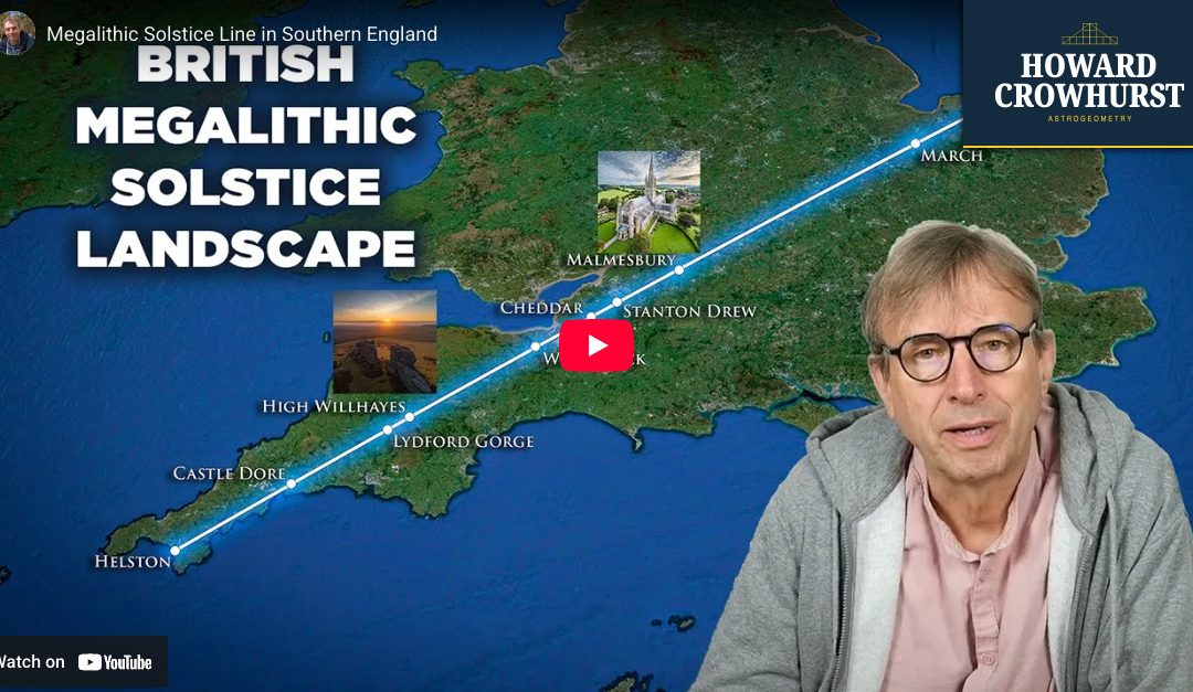
The journey begins with a clue from Roman author Pliny and 18th-century architect John Wood regarding the distance between the sacred island of Mona (Anglesey) and Camulodunum. The video demonstrates a precise 200-mile North-South alignment connecting the holy peak of Mona to Castle Dore in Cornwall.
-
The Dartmoor Gap & The Solstice:
From Castle Dore, the presenter reveals a stunning alignment. A line drawn at the exact angle of the Summer Solstice sunrise (approx. 51.93°) cuts directly through the “Dartmoor Gap”—the dip between the two highest peaks in Southern England (High Willhays and Yes Tor). This suggests the landscape itself was used as a gigantic astronomical instrument.
-
Points of Convergence:
Tracing this Solstice Line across the country, the video identifies a series of significant geographical and historical sites that fall perfectly on this alignment, including:
-
Lydford Gorge: The deepest gorge in the South West, which physically curves around the solstice line.
-
The Mendip Hills: specifically Will’s Neck (potentially translating to “Pass of the Sun”).
-
Stanton Drew: Where the line intersects the center of the Great Stone Circle.
-
Malmesbury Abbey: Once the site of England’s tallest spire, which would have provided line-of-sight visibility along this ancient track.
-
-
Sacred Geometry & The Golden Ratio:
The presentation goes beyond simple lines, diving into the complex mathematics of Stanton Drew. It illustrates how the stone circles utilize the surrounding hills to account for delayed sunrises, creating a “Golden Triangle” geometry ($1 : \sqrt{\phi} : \phi$) identical to the slope of the Great Pyramid.
-
Mythology meets Topography:
Throughout the analysis, the video weaves in connections to King Mark of Cornwall, King Arthur, and the Veneti tribe, suggesting that myths may be encoded memories of this ancient landscape organization.
Why Watch:
This video challenges the view of Neolithic builders as simple farmers, revealing them instead as sophisticated surveyors who harmonized their monuments with the earth’s topography and the movements of the heavens. Watch the full video to see the Google Earth flyovers that visually prove these incredible connections.